

Water Management
- Lower George River Flood Management
- Recreational Water Quality Monitoring
- St Marys Flood Risk Management
UPDATED: 9 February 2024.
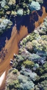
Break O’Day Council and the Lower George Riverworks Trust have just released their preliminary report on the effects of Meetermer (George River) changing course, and its implications as part of the Lower George River Avulsion Impact Assessment project (see documents below) and input is now being invited.
LwrGrgeR Avulsion Consequences – Prelim-Report presentation Feb 2024
LwrGrgeR Avulsion Consequences & Mgt Options – Prelim-Report Feb2024
Want to share your feedback on this project?
 Use the online survey questions on George River Floodplain – Avulsion consequences and management options HERE.
In November 2023 a community information workshop for the project examined ‘avulsion’ – the natural processes of rivers to change course – and its impacts on the floodplain. You can view presentation slides form that information session HERE.
Background and Past Flood Risk Management Work
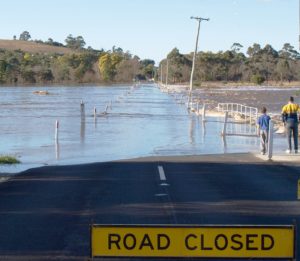
Flooding and changes to the floodplain of the Lower George River have been of concern to the community, landowners and Council for many years. Farming and tourism enterprises, public infrastructure and homes are threatened by floods and river changes on the floodplain. We are working with the Lower George Riverworks Trust to understand flood threats on the floodplain and manage the risks to the community and local economy.
In 2006 the Lower George Riverworks Trust was established as a body to manage erosion, sedimentation and flood issues on the lower reaches of the George River near St Helens. The Trust was formed as part of a project funded by the national/state Natural Disaster Mitigation Programme which undertook major rock armoring works to protect an eroding river bank in 2007.
While that work has been a success, on the the floodplain in particular flooding is a continuing risk for landholders, the community, infrastructure managers and the local economy. A flood risk assessment was completed for the floodplain in 2013 and a series of related projects have extended this work to consider inundation risks around Georges Bay and the added implications of projected climate change.
Following the 2016 floods in Tasmania the Lower George Riverworks Trust obtained funding support from the Tasmanian Agricultural Landscape Rehabilitation Scheme for a waterway investigation to identify river management strategies to reduce flood risks. This investigation highlighted the risk of the river channel breaking out and cutting a new course across the floodplain due to historical high sediment loads building up in the current channel.
In response the Trust has developed an Action Plan with Council. The River and Flood Management Action Plan aims to minimize rates of sediment deposition and flooding on the floodplain, while strategies for coping with the risk of the River taking a new course are developed.
View and download relevant studies and reports here.
Georges Bay Coastal Inundation Vulnerability Study 2011
Georges Bay – Tasmanian Coastal Climate Adaptation Pathways Project 2012
Lower George River Floodplain Risk Management Plan 2013
We have a water quality monitoring program over summer for natural waters popular for public recreation such as swimming.
Council follows the Tasmanian Recreational Water Quality Guidelines for the monitoring of recreational waters required by the Public Health Act 1997 and in consultation with the Tasmanian Department of Health. The monitoring and advice to the community are to assist people to determine where they should go for a swim or other water-contact activities.
All natural waters may be subject to local poorer water quality from time to time due to weather or other conditions. Its a good idea after significant rainfall to avoid whole body contact (swimming) for several days in waters receiving runoff from the land.
Water sampling is conducted by our Environmental Health Officer once a month from December to March. The results are based on a microbial standard for primary contact (swimming), Enterococci per 100ml, as an indicator of faecal contamination.
Good water quality: Enterococci/100ml less than 140
Conditions safe for swimming. The water may be subject to short-term advisories, eg. to avoid whole body contact (swimming) for several days after heavy rainfall.
Moderate water quality: greater than 140 and less than 280
Conditions generally safe for swimming, however consistent intermittent failures are noted and follow up is required to investigate the causes of elevated bacterial levels. The water may be subject to short-term advisories, eg. to avoid whole body contact for several days after heavy rainfall.
Poor water quality: two consecutive samples greater than 280
Possible risk of illness if you ingest the water. The water body is considered to be unsuitable for whole-body contact (swimming). Further follow-up is required to investigate causes to elevated bacterial levels.
Natural Recreational Water Quality Monitoring Results
2025-2026 Season
| Recreational water body | Date | ||||
| 03 Dec. 2025 | 12 Jan. 2026 | 16 Feb 2026 | 16 Mar 2026 | ||
| Grants Lagoon mouth B (deeper water) | Good | Good | Good | Good | |
| Grants Lagoon footbridge | Good | Good | Good | Good | |
| Grants Lagoon (campground) | Good | Good | Good | Good | |
| Beauty Bay | Good | Good | Good | Good | |
| Yarmouth Creek | Good | Good | Good | Good | |
| Wrinklers Lagoon | Good | Good | Good | Good | |
| Scamander River mouth | Good | Good | Good | Good | |
| Henderson Lagoon | Good | Good | Good | Good | |
| Denison Rivulet | Good | Good | Good | Good |
Last Seasons Monitoring Results (2024-2025)
| Recreational water body | Date | ||||
| 30 Oct. 2024 | 10 Dec. 2024 | 20 Jan. 2025 | 24 Feb. 2025 | 17 Mar. 2025 | |
| Grants Lagoon mouth (deeper water) | N/A | Good | Good | Good | Good |
| Grants Lagoon footbridge | N/A | Good | Good | Good | Good |
| Grants Lagoon (campground) | N/A | Good | Good | Good | Good |
| Beauty Bay | N/A | Good | Good | Good | Good |
| Yarmouth Creek | N/A | Good | Good | Good | Good |
| Wrinklers Lagoon | N/A | Good | Good | Good | Good |
| Scamander River mouth | N/A | Good | Good | Good | Good |
| Henderson Lagoon | Good | Good | Good | Good | Good |
| Templestone Lagoon | N/A | Good | N/A | Good | Good |
| Denison Rivulet | N/A | Good | Good | Good | Good |
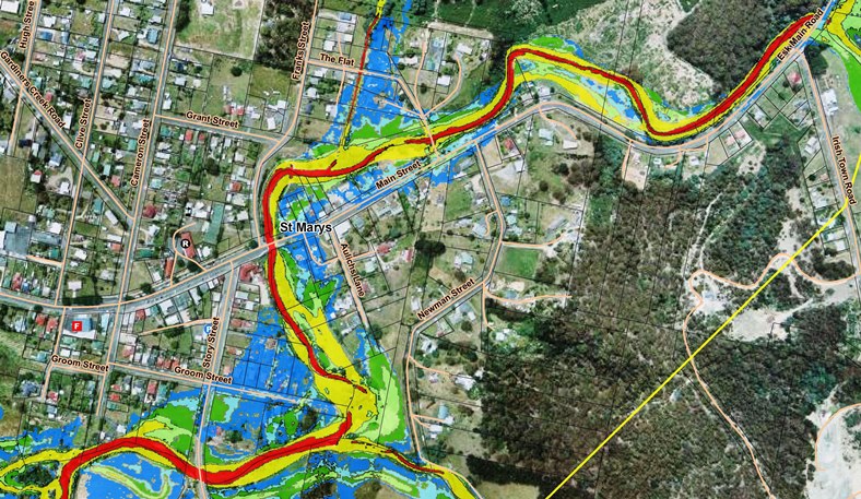
The St Marys Food Risk Management Plan is our action plan for managing township flood risks along St Marys Rivulet. This plan was finalised in February 2019 and implements the findings and priorities from the St Marys Flood Risk Management project which was undertaken following floods that impacted the St Marys community in 2016.
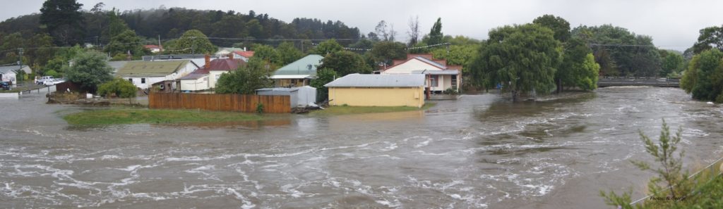
A flood risk mitigation project was undertaken between 2019 and 2021 using a $400,000 grant from the Australian Government for flood mitigation works and other actions in the plan. Priorities in the St Marys Food Risk Management Plan include
- early flood warning (of flash floods such as on January 2016)
- community wide flood preparedness and response planning for when floods occur again
- mitigation works (priorities being manage vegetation to improve flows but not impact the stream; a low levee to the north of Groom Street to reduce impact on housing; and modification of The Flat Bridge.
The flood modelling also provides information on what areas are prone to flooding along St Marys Rivulet through the township, which can be used to avoid flood risks for future land use and development.
You can view and download the St Marys Flood Risk Management Plan here.
The community and others such as the SES participated in the St Marys Flood Risk Management project during 2017-2018 to test flood mitigation options with flood models developed from 2016 flood data. Council received funding from the Natural Disaster Resilience Grants Program through the State Emergency Service to undertake this flood modelling and risk management with the St Marys community. As part of the project the community participated in identifying the recommended priorities for mitigation works and other strategies now included in the St Marys Food Risk Management Plan.
The St Marys Flood Risk Management project produced two reports in 2018
- Flood Risk Investigation Report on the flood models developed and flood risk mapping
- Flood Risk Management Report, testing mitigation options and recommending flood management strategies.
To support flood resilience in the community the reports and information in them is available for the households, businesses, infrastructure managers and emergency management groups and authorities to use for their own flood management responsibilities.
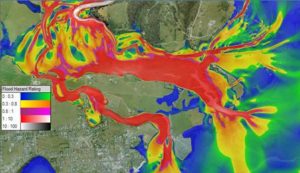
The flood maps from the Flood Risk Investigation report can be viewed with an online map viewer here.
You can view and download the reports from the links below. The Flood Risk Investigation report is large and its map sets are provided separately.
St Marys Flood Risk Investigation Report – body
Flood Maps – St Marys Risk Investigation Report
Flood Hazard maps – St Marys Flood Risk Investigation Report
Flood Function – St Marys Flood Risk Investigation Report
Climate Change Maps – St Marys Flood Risk Investigation Report
Full Land Use Maps – St Marys Flood Risk Investigation Report
St Marys Flood Risk Management Report
Options for modification of ‘The Flat’ bridge, one of the priorities for flood mitigation work, have undergone further testing with the flood models to identify which one provides the best reduction in flood risk to Main Street residents, businesses and the community. These flood model results are in the memorandum report you can view and download here.