


Current Projects and Activities
- Liveability Survey
- Memorial Park Toilet Upgrade
- Break O’Day Aquatic Facility Feasibility Analysis
- St Marys Early Childhood Needs Analysis
- St Helens General Cemetery Master Plan
- Scamander Coastal Hazards and Flood Risk Adaptation Pathways Project
- Scamander- Beaumaris Structure Plan
- Bay of Fires Master Plan
- Strategic Land Use Project - Industrial Land Use Study
What helps you live well in Break O’Day?
What makes Break O’Day a good place to live? What keeps you here—and what could make life better?
Break O’Day Council is inviting people from across our municipality to complete our Liveability Survey. We want to understand what matters most to our community, from housing, health and transport to employment, public spaces, community connections, recreation and the natural environment.
Whether you have lived here all your life or have only recently made Break O’Day home, your experiences and ideas are important.
The feedback received will help Council better understand our community’s priorities and inform future planning, decision-making and advocacy.
Complete the survey by October 6
Want to know more about the Liveability Framework Project? You can find out more here:
BODC Strategic Liveability Framework
Council is upgrading the existing public toilet block at Memorial Park, 37–39 Cecilia Street, St Helens.
Construction will commence on Monday, with the redevelopment delivering modern, accessible and more durable public amenities for residents and visitors. The facility will remain in its existing location and footprint.
What is being delivered?
The existing amenities block is being refurbished and reconfigured to include:
- modernised male and female amenities
- an accessible, DDA-compliant toilet
- upgraded fixtures and finishes
- a dedicated cleaner’s store
- upgraded internal services
- new internal and external building elements
- improved durability and functionality for long-term community use.
The works include demolition of the existing internal structures and construction of a new internal layout within the existing building footprint.
Architectural plans for the redevelopment are available below.
Why is the upgrade needed?
The project will renew an ageing public facility and improve its accessibility, durability and overall functionality.
Memorial Park is an important and well-used community space in central St Helens. The redevelopment will ensure the amenities better meet the needs of residents, visitors and people with disability now and into the future.
The project supports Council’s commitment to providing quality infrastructure that enhances the liveability of our communities.
Project timing
Construction will commence on Monday 27 July and is expected to be completed by November 2026.
The completion date may change due to weather, contractor availability or unforeseen construction issues.
These dates may change due to approvals, contractor availability, weather or unforeseen construction issues.
Access during construction
The existing Memorial Park toilets will be closed while construction is underway.
Public access to Memorial Park and the memorials will be maintained, and disruption to the broader park area is expected to be minimal.
Alternative public toilets are available at:
- Portland Hall, accessible through the front entrance from Monday to Friday, 10am to 2pm
- St Helens Wharf
- St Helens Visitor Information Centre.
Council will provide further information about access arrangements and any temporary disruptions as the project progresses.
Community information
As the project upgrades an existing facility within its current footprint and does not significantly change the use of Memorial Park, formal community consultation was not required.
Council consulted directly with the St Helens RSL Sub-Branch due to its lease arrangements and ongoing use of the Memorial Park area. The Sub-Branch confirmed its support for the project.
Council will continue to keep the community, nearby businesses and park users informed about:
- construction timing
- temporary toilet closures
- alternative facilities
- access arrangements
- any expected disruption.
Project budget
Council has allocated $400,000 for the project through its 2026/27 Capital Works Program.
Project updates
Updates will be published on this page as the project progresses.
See the plans below:
BRIEF PROJECT DESCRIPTION:
The Break O’Day Council is exploring the potential construction and operation of an Aquatic Facility in our area. The project initially involves a feasibility analysis to assess whether such a facility is viable. This analysis will examine the various components of the proposed aquatic facility, including its design, potential locations, and the anticipated level of community use. Additionally, the financial projections will be broad and consider the community’s ability to fund the project. The primary goal of the feasibility analysis is to address key questions, such as whether an aquatic facility is feasible, what it could look like, where it might be located, and how it would be financed.
Break O’Day Aquatic Facility Feasibility Study Final Reports
We are pleased to provide you with the finalised Aquatic Centre Feasibility Study Report from Otium Planning Group. This Report has been developed from extensive work by Otium, Council officers and Council’s Aquatic Facility Working Group. A big thank you to everyone involved for the work which has been completed.
As an introduction we have prepared a short explainer video which introduces the project and covers the key findings:
Click below to view the full report:
BOD Aquatic Feasibility Report
To help break down what the Feasibility Study means for our community, we’ve also prepared the following supporting documents and resources:
Frequently Asked Questions (FAQ) Sheet
Community Focused Executive Summary (November 2025)
Economic & Social Benefits Assessment (August 2025)
“Can We Afford It?” Financial Assessment (November 2025)
COMMUNITY SURVEY ROUND 2 CONSULTATION NOW CLOSED:
Thank you to everyone who took the time to take the survey.
You can find the full Consultation Report below.
Aquatic Facility – Consultation Report – Round 2 FINAL
This report has now been endorsed by Council.
Council decided to progress the Aquatic Facility to a Business Case at the April 20 Council Meeting.
The investigations and ultimately decision making around a potential Aquatic Facility in the area will be the most complex and ultimately future shaping project to be considered by the Council since the amalgamation of Portland and Fingal Councils creating Break O’Day in 1993. A decision to build and manage an Aquatic Facility will be lived with for future generations.
If progressed, the construction of a facility will require external funding, meaning Council will need to seek State and Federal funding to deliver such a project.
Thank you for taking the time to find out more about this project. It has taken longer than we originally envisaged and we apologise for this, but that has been about us making sure all of the information is available to the community to have a complete understanding about the project and what it means. We appreciate you taking the time in reviewing the information and encourage everyone to stay informed as the project progresses.
CONSULTANTS:
Otium Planning Group
KEY ACTIVITIES & INDICATIVE TIMELINES:
| DATE | ACTIVITY | DETAIL |
| August-September 2024 | Pre-Research | Reviewing all background studies, demographics etc. Reviewing competitor facilities and aquatic trends. This will inform a Needs gap analysis |
| Late October – Early December | Community Engagement | This will include:
|
| November | Research comparable facilities | Examining three rural or similar facilities |
| January 2025 | Component Schedule | Outlining what the facility would require to help guide site capability discussions |
| Cost Plan | Based on agreed components, a high level cost plan will be developed | |
| Financial Monitoring | Develop a detailed financial model and investigate potential funding opportunities | |
| February 2025 | Draft Feasibility Study | A Draft will be presented to Council for discussion. After it has been to Council it will be released to the community for their input. |
| February – March 2025 | Community Feedback | Community feedback on the draft will be collated and considered in the final version |
| March 2025 | Final Feasibility Report | Will be released to the public and uploaded to Council’s website. |
* It is important to note that the Key Activities and Timelines are indicative only and that they may evolve and change as the consultancy progresses.
COMMUNITY ENGAGEMENT OPPORTUNITIES:
There will be several opportunities for the community to have their say on the Aquatic Feasibility Study project. We will share links and promotions to these opportunities here as they arise. We will also promote these opportunities through our Newsletter, Social Media and email databases as well as other local media outlets.
INTRODUCTION:
Break O’Day Council, in partnership with the Eastern Strategic Regional Partnership and with support from the Tasmanian Government, is leading a comprehensive Childcare Needs Analysis for St Marys and Tasmania’s East Coast. To deliver this important work, we have engaged Ninety Mile Consulting (NMC), who bring strong experience in regional early childhood planning.
This project will help us better understand the current and future needs for early childhood education and care (ECEC) and outside school hours care (OSHC) across our communities. The aim is to identify sustainable service models, potential sites for new or expanded services, and workforce strategies that improve the availability and accessibility of childcare for families across the East Coast.
Council recognises that strengthening early years services requires genuine collaboration. This project reflects local and state governments working together, supported by expert consultancy, to build a clearer picture of what our region needs now and into the future.
Across Tasmania’s East Coast, families are navigating long travel distances, seasonal work patterns, and limited childcare availability — challenges that are common across regional Australia but often more pronounced in smaller communities like St Marys. Understanding these local realities is essential to planning services that are stable, accessible and fit-for-purpose.
Through local engagement, demographic analysis, and strategic planning, this Needs Analysis will produce practical, actionable recommendations. Break O’Day Council and NMC are working closely with community members, service providers, and government partners to ensure the findings reflect lived experiences and support long-term, sustainable early years outcomes for our region.
UPCOMING EVENTS
Online Information session
Monday 24 November 2025 from 4pm
To register – contact: matt@ninetymileconsulting.com
SUPPORTING DOCUMENTS:
St Marys & East Coast Tasmania ECEC & OSHC Needs Analysis Compressed
Summary Document Tasmania East Coast ECEC & OSHC Needs Analysis – Break O’Day Council
INTRODUCTION
The St Helens General Cemetery is entering a new chapter with the commencement of Stage 1 of the Cemetery Master Plan—the creation of a Remembrance Garden. This work forms part of Break O’Day Council’s long-term commitment to enhancing local cemeteries, creating peaceful spaces that support reflection, remembrance, and community connection.
PROJECT DETAIL
In 2014, Break O’Day Council collaborated with Lange Design and the community to develop master plans for the cemeteries in St Helens, St Marys, Fingal, and Mathinna. These plans aimed to transform the sites into more serene, garden-like spaces that are welcoming, respectful, and comforting for families and visitors.
The first stage of the St Helens General Cemetery Plan will see the construction of a Remembrance Garden—a quiet and calming space designed for contemplation and tribute. This is a significant and sensitive project that honours the wishes of the community and reflects Council’s commitment to respectful public spaces.
TIMELINE:
Start Mid-August 2025 (weather permitting)– expected 8 weeks to complete
Disruption: Minimal to none; the cemetery will remain accessible to visitors throughout the works
STRATEGIC ALIGNMENT
This project aligns with several objectives outlined in the Break O’Day Council Strategic Plan, including:
Community – Foster a supportive and welcoming community.
The Remembrance Garden provides a peaceful, inclusive space for all community members to remember loved ones.
Environment – Promote and enhance our natural and built environment.
The garden will enhance the cemetery’s landscape, supporting biodiversity and improving amenity.
Infrastructure – Maintain and improve local infrastructure and facilities.
This project improves the functionality and experience of a key community space.
Project Budget
The Stage 1 works, including landscaping and garden development, have been budgeted as part of Council’s current capital works program.
Cost for Stage 1 Remembrance Garden: $50,000
Click the links below to view the design concept plans:
LATEST NEWS
Grant Funded Project Nearing Completion
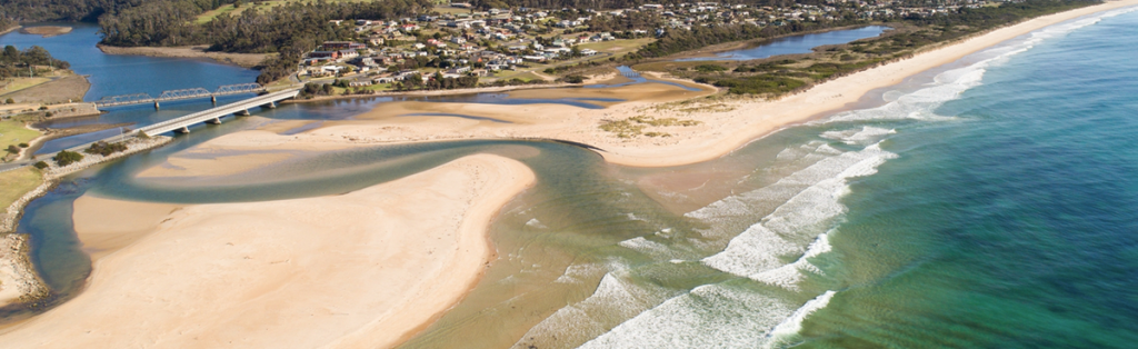
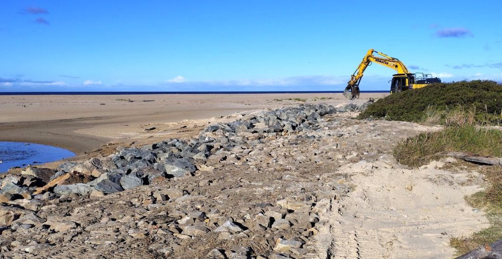
Works to repair the degraded rock wall (revetment) in front of Scamander River mouth park and stabilise an erosion bank next to Dune Street using over 200 tonnes of rock were completed in August 2026. These works, along with revegetation afterwards, aim to control erosion and hold the shoreline position in the short-term. They are low level and won’t stop inundation by floods and high seas.
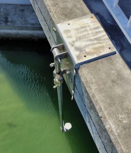
An automated water level sensor has been installed on the Scamander bridge for improved management of a closed barway to reduce the risk of inundation and give warning of flooding water levels.
These follow the investigations and planning work completed earlier in the year on coastal and flood hazard processes, risks and the final Scamander Coastal Hazards and Pathways Adaptation Plan.
This adaptation planning work by the project identified the recent on-ground works for immediate risks at the River mouth. The Plan shows there are no easy fixes for uncertain coastal and flood risks in future and recommended these ‘no-regrets’ mitigation measures to avoid maladaptation. And it provides advice for developing stronger management interventions in future and prudent decisions to adapt to the shifting coastal and flood risks over time. The Scamander Coastal Hazards and Pathways Adaptation Plan is a shared resource for shared risks, that anyone facing the can use for their own pathways of future decisions and risk management actions.
View and download a copy of the Scamander Coastal Hazards Pathways Adaptation Plan here.
See our Natural Hazards webpage for more on the coastal and flood hazards, including work done for this Scamander project on understanding their natural processes and risks in future.
______________________________________________________________
Project Blog
Information Gathering and Community Workshop June 2025
In the first stage of the project in June the consultant team visited Scamander to collect site information and hear from the community and meeting with several community members and stakeholders to look at the River Mouth.
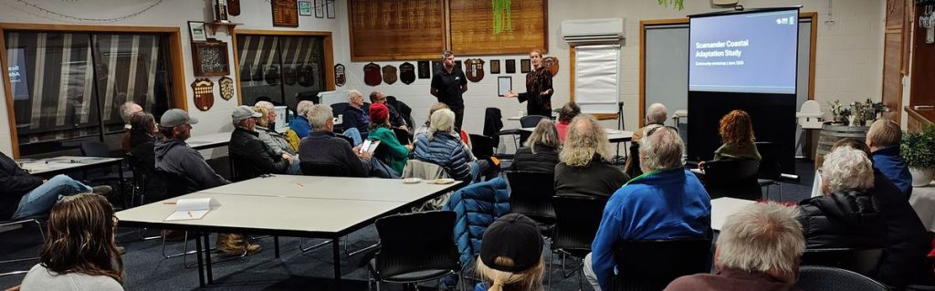
Ellen Witte from SGS and Nick Lewis from Moffatt & Nichol delivered a presentation and facilitated discussion with participants. View an annotated copy of their presentation slides from the workshop here (6Mb) , it includes links on some slides to sources of more detailed information you can explore.
First online questionnaire – River Mouth history and things people care about
This questionnaire asked people to share photos and recollections from the past. It asked what things people care about that are exposed and vulnerable to stormy seas and floods already and for their ideas for what to do in the future.
September Community Workshop – Hazards and Exposed Assets
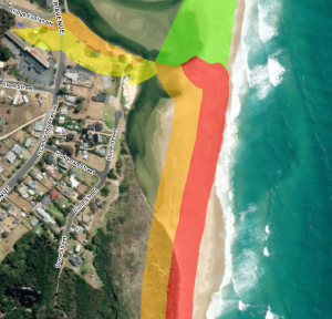
Participants discussed assessments of the coastal and flood hazards at the River Mouth and the assets and values there that are at risk.
- The Outlook report – Scamander Coastal Hazards & Flood Risks and Climate Change by Nick Lewis from Moffatt & Nichol (see a short summary of this technical report here)
- A presentation on that study and work consultants were doing to identify assets and values at the river mouth potentially exposed to the coastal and flood risks. View the September workshop presentation slides here.
October Community Workshop – Hazards and Exposed Assets
Discussion and ideas were shared to help plan future coastal and flood hazard management and adaptation for different parts of the Scamander River Mouth. For key shoreline sites scenarios of adaptation measures and interventions were discussed. Download the workshop presentation slides here.
Second online questionnaire
This followed up the September and October workshops for further input on the hazard management scenarios and mitigation measures for key shorelines, for managing the risks with long term planned adaptation pathways.
Coastal hazard management options for Dune Street shores
A memorandum report was produced following the October workshops describing three options for the Dune Street shores ranging from low to high levels of intervention. These were to be evaluated in the adaptation planning process, which then helped identify ‘no-regrets’ on-ground mitigation works to then be planned, designed and constructed by the project. They included a
- low key nature-based solution (NBS) to address erosion in the short term
- hybrid NBS/hard seawall to address longer term erosion and small wave runup with a low bund
- seawall/flood levee to address erosion and inundation in the long term.
You can download the Dune Street shoreline protection memorandum report here.
Draft Hazards and Pathways Adaptation Plan February-March 2026
The draft Scamander Coastal Hazards and Pathways Adaptation Plan documented the cost/benefit evaluation by the consultants of the three mitigation options, focussing on the southern Dune Street shoreline. It also applied the results at Dune Street to other coastal hazard sites and considered other alternatives and issues that had been raised. Recommendations were made on the mitigation options for Dunes Street and other sites, ‘adaption pathways’ and land use planning to avoid future risks and losses. You can view the Draft Hazards and Pathways Adaptation Plan here.
Third online questionnaire
This was used for community input on the draft Plan, with questions focussed on sections of the draft Plan. you can view a report on the draft Plan consultation here
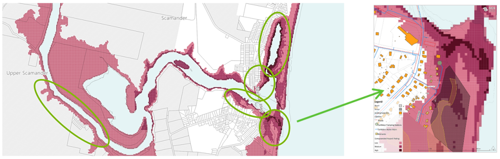
Final Scamander Coastal Hazards and Pathways Adaptation Plan
After incorporating feedback and input on the draft the final Scamander Coastal Hazards and Pathways Adaptation Plan was received by Council in April 2026.
View and download a copy of the Scamander Coastal Hazards Pathways Adaptation Plan here.
Mitigation works
No-regrets risk mitigation works to repair remains of the degraded rock wall (revetment) of the old training wall in front of the park, and installation of automated water level sensor to monitor conditions with a closed barway, were completed during in September 2026.
Next steps
This final on-ground work will complete the Scamander Coastal Hazards and Flood Risk Adaptation Pathways Project and its grant funding from the Australian Government’s Coastal and Estuarine Risk Mitigation Program 2022–23.
People have been facing coastal and flood hazards at the River mouth and the risks they pose for 10s and 100s of years. The project has identified a way to navigate through the uncertain but increasing risks that Climate Change will bring in these hazards with Adaptation Pathways of options and future choices to be made. It will be up to community, River mouth residents and businesses and agencies and governments to apply it to their individual and shared interests, risks and benefits.
Council, from the perspective of its own regulatory responsibilities, assets and services and community and stakeholder interests, can use it to plan its own adaptation pathways. Future coastal hazard management options and priorities may need others facing the same risks to be involved and would require substantial investment, investigations, pre-planning and resources to implement.

__________________________________________________________________
The Scamander Coastal Hazards and Flood Risk Adaptation Pathways Project was funded by the Coastal and Estuarine Risk Mitigation Program 2022–23. An Australian Government initiative, in Tasmania with the State Emergency Service.
PROJECT UPDATE:
Scamander-Beaumaris Draft Structure Plan – Have Your Say!
We’re planning today for the towns we want tomorrow. The Draft Structure Plan for Scamander-Beaumaris is open for community feedback from Monday 3rd to Sunday 30th November 2025.
Visit www.scamander-beaumaris.com to view the Draft Structure Plan.
Join ERA at a community workshop or pop-up session:
- Scamander IGA X-press: Wednesday 12 Nov, 2:00–4:00pm
- River Mouth Café: Thursday 13 Nov, 8:00–10:00am
- Community Workshop @ Scamander Sports & Community Complex – Wednesday 12 Nov, 5:30–7:30pm. RSVP via the website.
Prefer to have your say online? Visit www.scamander-beaumaris.com to take the survey and learn more or download a copy Community Survey
Hardcopies are also available at Council offices.
PROJECT UPDATE:
Following the first round of community consultation on the Scamander-Beaumaris Structure Plan in July and August this year, Era Advisory and Playstreet have now published the Consultation Summary on the project website. Head on over to read the summary and find out what the local community had to say!
- 700+ visitors to the project website
- 55+ people attended a pop-up session
- 130 responses to the online survey
- 11 written submissions
Read the full summary here: https://www.scamander-beaumaris.com/
PROJECT DESCRIPTION:
Break O’Day Council are preparing a Structure Plan for the Scamander-Beaumaris area and has partnered with Era Advisory and Playstreet who will be undertaking community consultation and developing the plan.
The Plan will create a shared vision for the townships and guide future land uses in the area and we want to hear your thoughts!
We’re also seeking your ideas for improvements at the Scamander Sports and Community Complex.
How to get involved:
There are several ways you can share your thoughts – head to the project website to find out more about Community Engagement times, online surveys and read the discussion paper.
BRIEF PROJECT DESCRIPTION:
Parks & Wildlife Service (PWS) and Break O’Day Council (BODC) have partnered to engage a consultant to prepare a Bay of Fires Master Plan that will deliver a high quality environmentally, economically and socially sustainable Bay of Fires experience for the next twenty years to 2040. To deliver on that objective, the Master Plan must have regard to the need for protection and enhancement of the natural environment and cultural values, the needs of the community and residents, and he nature and drivers of the local economy. The primary scope encompasses national park, conservation and recreation areas north of Humbug Point, to the Binalong Bay township, the Bay of Fires beaches and campgrounds, Anson’s Bay, to Deep Creek in the north and the freehold land within this area.
CONSULTANTS:
Hansen Partnership Pty Ltd
KEY ACTIVITIES & INDICATIVE TIMELINES:
| Commencement Date | Activity | Detail |
| Last week October, 2024 | Inception | · Inception meeting
· Initial contact with Aboriginal parties · Preparation of Project Plan · Preparation of Engagement Plan |
| First week December, 2024 | Desktop Review & Initial Management | · Confirmation of Aboriginal engagement
· Background review · Community & tourism summaries · Targeted engagement · Impacts and Opportunities · Initial Cultural Heritage Assessment |
| Mid February, 2025 | Concept Framework | · Conceptual Framework development |
| Mid April, 2025 | Testing | · Site investigations and community engagement
· Further engagement with Aboriginal parties · Cultural Heritage assessment · Existing conditions analysis |
| Mid May, 2025 | Draft Masterplan | · Preparation of draft Masterplan
· Preparation of draft Infrastructure Guidelines |
| End July, 2025 | Finalisation | · Finalisation of Masterplan
· Community Engagement · Preparation of Engagement Summary |
These activities and timelines may be subject to changes during the duration of the project
COMMUNITY ENGAGEMENT OPPORTUNITIES:
There will be several opportunities for the community to have their say on the Bay of Fires Master Plan project. We will share links and promotions to these opportunities here as they arise. We will also promote these opportunities through our Newsletter, Social Media and email databases as well as other local media outlets.
For the latest community engagement opportunities regarding the Bay of Fires Master Plan click here: https://www.bodc.tas.gov.au/community/community-consultation/
For more information on this project visit: https://bayoffiresmasterplan.org
WHAT HAPPENS TO THE REPORT:
The Bay of Fires Master Plan will provide a basis for managing the future use of the Bay of Fires area to deliver a high quality experience for those who visit and use the area. It will guide the actions and priorities of the Parks and Wildlife Service who have the overall land management responsibility for the Bay of Fires as well as the activities of the Break O’Day Council and other community organisations who have an interest in the area.
UPDATED – 18 JUNE
SURVEY NOW OPEN – Head to our Community Engagement Page to share your thoughts with us by CLICKING HERE.
Why an Industrial Land Study?
Council’s Development Services are commencing a strategic land use project to identify a forward supply of industrial land within our local government area. A forward supply of industrial land is important in ensuring sufficient land is available to support new or expanded activities and incentivise diversity within industry. The objective is to place the Break O’Day local government area in the best position in terms of industrial land supply, to meet demand, to provide opportunities for emerging or expanding sectors and entrepreneurship and to support its residents in terms of liveability and well-being. Diverse and sustainable industry relies on choice and flexibility in terms of location, freedom of operation, land size, access to services, resources and transport networks.
An aspirational goal of identifying adequate and appropriate ‘industrial’ land is the Break O’Day municipality can increase the diversity of employment sectors and provide significant economic and community benefits including job creation, investment and entrepreneurism.
What Happens Next?
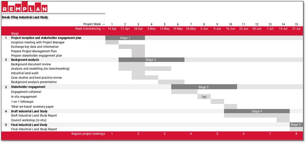
The project will be undertaken by REMPLAN in partnership with Council. REMPLAN brings extensive experience in industrial land analysis, economic modelling and strategic planning, with a strong track record of delivering similar studies for regional councils across Australia. Their approach integrates quantitative economic analysis with qualitative stakeholder insights as we aim to ensure the study is practical, market responsive and aligned with local conditions. Below is an indicative timeline of the project with milestones identified. As you can imagine we want the project to be responsive to findings and will be consulting with our local community stakeholders.
How can I get involved?
Stakeholder engagement is an important part of this project and as the engagement strategy is finalised, more information will become available on this page as well as other communication channels. REMPLAN have access to an extensive stakeholder database and so further information will be coming soon.
At this stage it is likely that the final report will be delivered in July 2025 and publicly available soon after.
*Timelines are subject to change based on how each stage of the project progresses.
For more information:
Contact Council on telephone 6376 7900 or email admin@bodc.tas.gov.au.
You can find a list of Upcoming Works activities here: